

Characterizing the rate of spread of large wildfires in emerging fire environments of northwestern Europe using Visible Infrared Imaging Radiometer Suite active fire data

Adrián Cardil Forradellas, PhD., director of fire science at Tecnosylva
This article investigates how large wildfires propagate in northwestern Europe, a region historically considered temperate and low-risk but which in recent years has experienced unusually large and destructive fires. Events such as record-setting fire seasons in the United Kingdom in 2018 and 2019, as well as the Netherlands’ largest wildfire in decades in 2020, have raised concerns that fire regimes are shifting northward. Climate projections indicate warmer, drier conditions in coming decades, which will make such fire activity more frequent and intense. However, unlike fire-prone regions such as the Mediterranean, California, or Australia, relatively little is known about the actual behavior of wildfires in northwestern Europe, especially in terms of their rate of spread (ROS). ROS is a key parameter for fire danger rating and management because it captures how quickly flames move across landscapes. This study addresses that knowledge gap by developing and applying a novel method to characterize ROS using satellite active fire detections.
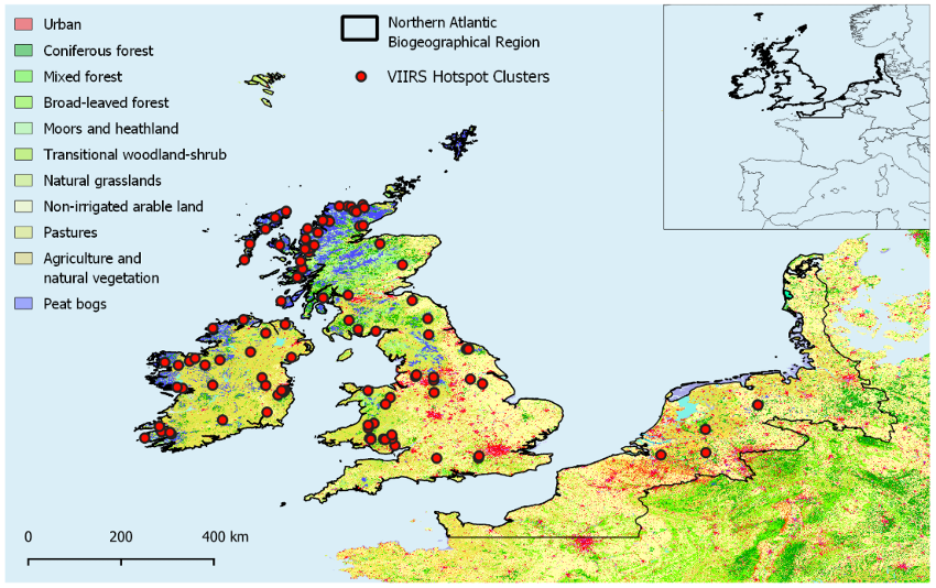
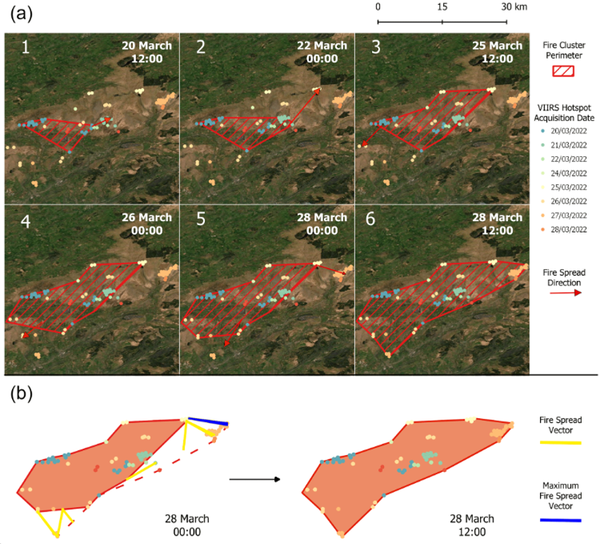
For this purpose, the VIIRS 375-m active fire dataset was used, which offers higher spatial detail than MODIS data and allows identification of fire fronts at sub-kilometer resolution. The approach consists of taking individual VIIRS hotspots, grouping them spatially and temporally into fire incidents, generating fire perimeters for consecutive satellite overpasses, and then calculating the distance and direction of spread between them. By comparing the outermost fire lines over a typical 12-hour revisit period, the authors derived vectors of maximum ROS for each fire. To avoid false detections from urban or industrial heat sources, only fires overlapping natural land cover types defined by the Corine Land Cover map were retained. This filtering step reduced an initial dataset of over 326,000 detections to just under 30,000 relevant fire points. Clustering and perimeter generation eventually yielded 102 distinct wildfire events between 2012 and 2022. From these events, 327 ROS vectors were extracted, representing estimates of how fast fire fronts moved across the landscape.
The results reveal several key patterns. First, wildfire activity in northwestern Europe is strongly seasonal, with about two thirds of the burned area recorded in March and April, and significant contributions in February and May. This suggests that the effective fire season in the region spans late winter into spring, rather than the classic mid-summer peak observed in Mediterranean or boreal systems. The calculated ROS values for this season are relatively modest by global standards. The overall mean ROS was around 0.07 kilometers per hour, with a median near 0.09 kilometers per hour during the March–April peak. The interquartile range was between 0.04 and 0.14 kilometers per hour, and only rarely did any individual fire exceed 0.34 kilometers per hour. These figures are far lower than the multi-kilometer-per-hour spread observed in extreme fire environments like Australia or California, but they still represent meaningful threats in densely populated European landscapes where suppression resources and infrastructures are vulnerable.
The study also investigated differences in ROS according to land cover type. Coniferous forests showed the highest median spread rates, about 0.19 kilometers per hour, consistent with expectations that needle litter and crown structure favor faster fire propagation. At the other extreme, transitional shrub and scrub vegetation had the slowest spread, around 0.04 kilometers per hour, and this difference was statistically significant. Other land covers such as grasslands, moors, peatlands, and pastures displayed intermediate rates of 0.08 to 0.14 kilometers per hour, with no significant differences among them. Interestingly, peatlands, although showing moderate ROS, were associated with very large burned areas. This is likely because peat fires smolder for long periods and are difficult to extinguish, producing extensive scars despite their slower frontal spread. The satellite method primarily captures surface burning rather than subsurface smoldering, which explains the discrepancy between spread rate and final area in peatlands.
Another important finding is the positive relationship between maximum ROS and final burned area: fires that spread faster were more likely to become large events. This correlation is consistent with fire behavior theory and underscores why ROS is such a critical variable for early warning and suppression planning. At the same time, the authors caution that the ROS derived from VIIRS should be interpreted as conservative, averaged estimates. Because VIIRS overpasses occur about every 12 hours, the method smooths over fluctuations within that interval, potentially underestimating peak spread during windy afternoons or flaring events. In addition, the 375-m resolution means that only fires larger than about 10 hectares are reliably captured, so the dataset likely misses many small but locally important events. Nevertheless, for characterizing landscape-scale fire dynamics over an entire decade, the approach is robust and offers insights unavailable from ground records, which are patchy or inconsistent in many European countries.
The implications of these findings are notable for fire management in northwestern Europe. First, they highlight that the critical fire season is concentrated in late winter and early spring, months that are not traditionally emphasized in Mediterranean-focused fire policy. Management agencies should therefore increase vigilance, preparedness, and resource allocation during February to May, particularly in areas with coniferous forests and peatlands. Second, the relatively modest ROS values should not lead to complacency, because fires spreading at only a few hundred meters per hour can still outpace suppression under windy conditions and threaten nearby communities. In landscapes with high population density and infrastructure, even moderate ROS can translate into severe impacts. Finally, the study demonstrates that satellite-based ROS estimation can be an effective tool for regions with limited ground-based fire behavior data. As satellite systems evolve, including planned higher-resolution missions like Canada’s WildFireSat, such approaches will become increasingly valuable for monitoring and forecasting emerging fire regimes.
At TEMA, fire analyses are being carried out in the Kainuu region of Finland, one of the project's pilot areas. This article provides information about fire regimes in the area and possible preventive measures, as well as basic parameters for general firefighting planning.