
Background Image for header that show a weather storm
tema logotipo
Home

Main navigation

  • Home
  • About
    • Description of the project
    • Partners
    • Governance
    • Glossary
  • Cluster
  • Pilots
  • Outcomes
    • Datasets and Publications
    • Public deliverables
    • Academic Contents
    • Dissemination materials
    • Videos
  • Updates
    • Articles
    • News
    • Events
    • Newsletters
  • Contact
  1. Home
  2. Satellite Products

Satellite products

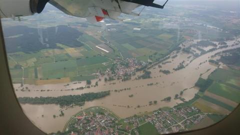
Satellite Mapping in the Field During the Flood in South Germany in May and June 2024

Coordination of Satellite Mapping in the Field During the Flood in South Germany in May and June 2024

Fri, 05/07/2024 - 10:00
In May 2024, southern Germany experienced relentless heavy rainfall for several days, particularly affecting the regions of Baden-Württemberg and Bavaria. For effective mission planning, it is crucial for teams to have access to up-to-date data, including maps, satellite images and orthophotos. This information is provided by the Center for Satellite-Based Crisis Information (ZKI) of the German Aerospace Centre (DLR).
Subscribe to Satellite products
Tema logo

Contact us

info@temaproject.eu

Join our newsletter

CC-BY Licence

Footer Links

  • Privacy
  • Cookies
  • Glossary
  • Accessibility Statement
  • Sitemap
EU Funded This project has received funding from the European Union’s HE research and innovation programme under the grant agreement No. 101093003