

Coordination of Satellite Mapping in the Field During the Flood in South Germany in May and June 2024

Uwe Kippnich, Bavarian Red Cross HQ
Margareta Mihalic Dogan, Bavarian Red Cross HQ
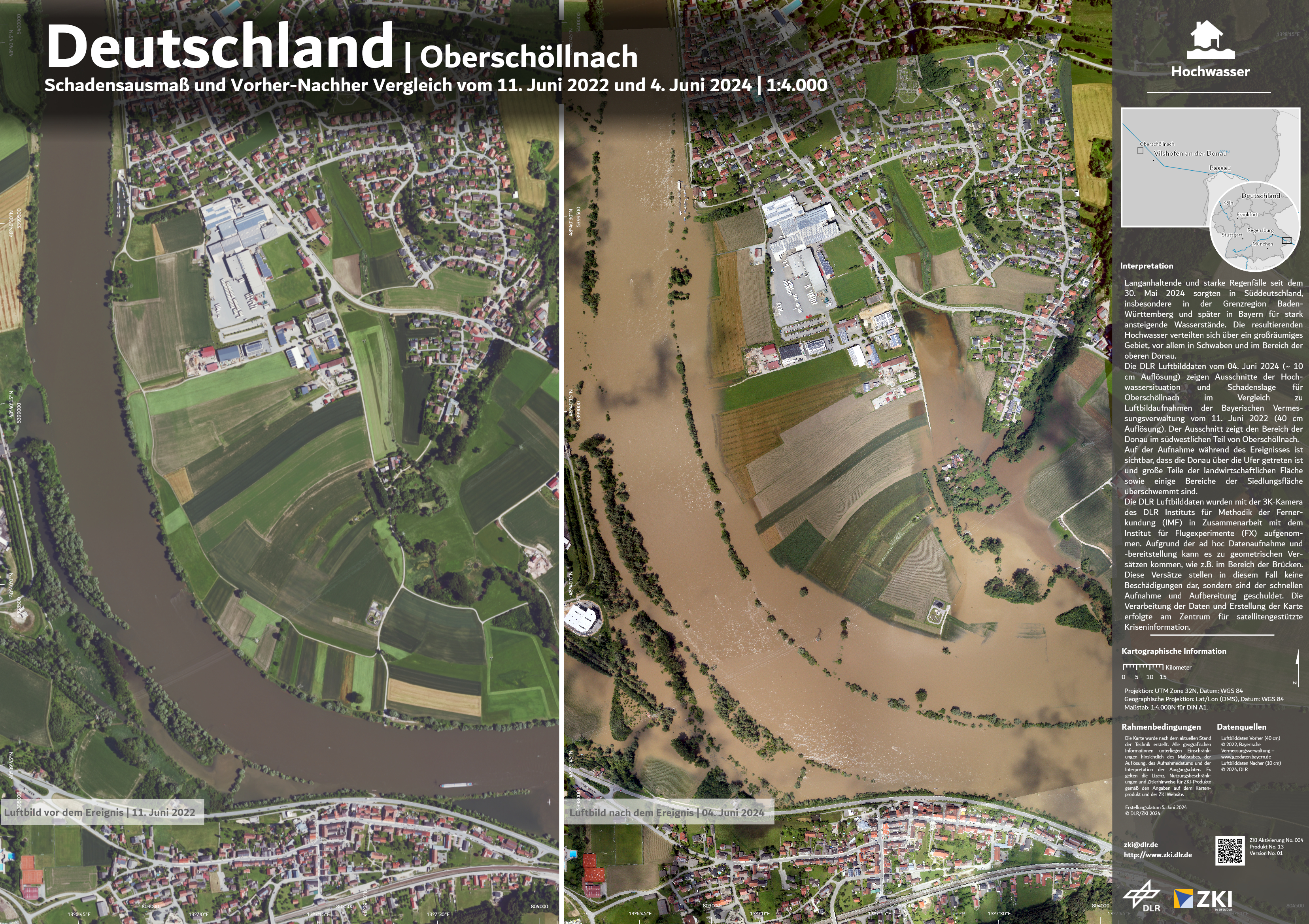
In May 2024, southern Germany experienced relentless heavy rainfall for several days, particularly affecting the regions of Baden-Württemberg and Bavaria. The subsequent floods spread over a vast area, devastating infrastructure across multiple states. Tragically, five people lost their lives, thousands were evacuated, and six individuals remain missing. Special water rescue teams and helicopters were deployed to evacuate some residents from their homes. The disaster prompted extensive public protection and disaster relief (PPDR) efforts involving the Bavarian Red Cross, fire brigades, rescue services, the German Armed Forces other organisations. These organisations carried out a range of tasks, including search and rescue operations (SAR), pumping water, preparing shelters and providing food. More than 52,000 rescuers were deployed to manage the crisis. During a visit to the disaster area, German Chancellor Olaf Scholz stated that the increasing frequency of such flooding events is a clear indication of climate change.
For effective mission planning, it is crucial for teams to have access to up-to-date data, including maps, satellite images and orthophotos. This information is provided by the Center for Satellite-Based Crisis Information (ZKI) of the German Aerospace Centre (DLR). Experts must identify areas of interest (AOI) where detailed information is required. The BRK research department team maintained constant communication between the field and the DLR centre. The BRK´s integrated command centre in Schweinfurt served as the central point of contact, receiving information from the field and relaying it to ZKI and vice versa. Shortly after receiving a request from the field, DLR provided maps and a web viewer that allows access to these products. The web viewer is an excellent tool for managing information, being user-friendly and requiring no separate training. The platform includes an overview with navigation instructions, making it accessible to all users. Available data includes satellite and drone orthophotos, as well as aerial images of the immediate crisis situation. To gather this data, DLR conducted airborne flights on Monday 3 June 2024 and Tuesday 4 June 2024. The teams in the operation, command post and field utilised this valuable information for assessments, team briefings and coordinating operations. Situation maps can be downloaded for free from the DLR-ZKI website. In onsite operation coordination centres (OSOCC) in the field, where internet access might not be available, maps can be printed out and displayed for briefings and other purposes.
Understanding the benefits of these products is crucial for commanders and staff. How can this understanding be achieved? A practical approach includes an initial presentation by DLR experts about satellite products, followed by training with the materials, followed by in a field exercise. In the training scenario, teams must send a request for maps. The integrated command centre requests the maps from DLR and provides them to the field teams. This procedure helps first responders understand the request process, the time needed and the usefulness of the products for their mission. Maps provide answers to critical questions such as which areas are affected, which bridges are usable, where the epicentre of the disaster is and how severely critical infrastructure is affected. Federal authorities can also request assistance from the German Joint Information and Situation Centre (GMLZ). GMLZ maintains contact with the Emergency Response Coordination Centre in Brussels, managed by DG ECHO. The European Centre activates other services like Copernicus, creates maps and provides these products on their website.
The successful partnership with the German Aerospace Centre in projects and training was the foundation for the effective work during the mission. This cooperation was not built overnight; it is the result of years of joint projects, training sessions and mutual understanding of each organisation's capabilities and requirements. During the floods, this cooperation proved invaluable as it allowed for seamless integration of satellite data into the disaster response efforts.
In addition to the immediate response, long-term planning and mitigation strategies are essential to handle such disasters more effectively in the future. This includes investing in better infrastructure that can withstand extreme weather events, improving early warning systems and enhancing public awareness and preparedness. The role of technology, especially satellite and drone imagery, will continue to be critical in these efforts. It provides real-time data that is crucial for making informed decisions during emergencies.
The collaboration between various agencies also highlighted the importance of having a well-coordinated disaster response framework. Each organisation brought its unique expertise to the table, creating a comprehensive response strategy. For instance, while the Bavarian Red Cross focused on providing immediate relief, medical assistance, water and mountain rescue, sheltering, field kitchen and more. The fire brigades were crucial in rescue operations and the German Armed Forces provided logistical support. This multi-agency approach ensured that all aspects of the disaster response were covered efficiently.
In conclusion, the floods in southern Germany in May and June 2024 were a strong reminder of the growing challenges posed by climate change. The response to this disaster showcased the critical role of technology, inter-agency cooperation and international collaboration. As we move forward, it is imperative to continue building on these foundations, investing in resilience and adopting a proactive approach to disaster management. By doing so, we can better protect our communities and infrastructure from the inevitable impacts of a changing climate.
Source:
Satellite maps from the flood: https://activations.zki.dlr.de/en/activations/items/ACT163/