

TEMA Highlight: Smoke Plume Modelling with Drone-based Ground Truth collection
![Cumulative Weekly Burned Area within the European Union due to wildfires, from the European Forest Fire Information Service [EFFIS], Statistics Portal.](/sites/default/files/2023-10/1.png "Image © EFFIS")
Victor Scott Prieto Ruiz, DLR.
Forest Fires in Europe: Overall trends
Ever since there have been forests, there have been wildfires spreading through them. With changing climates also come increasing risks of wildfires. The year 2022 was the second worst year on record in Europe from 2006 to 2022 according to the European Forest Fires Information Service, and 2021 and 2023 have also had cumulative burnt areas above the average of this time period.
![Cumulative Weekly Burned Area within the European Union due to wildfires, from the European Forest Fire Information Service [EFFIS], Statistics Portal.](/sites/default/files/inline-images/image_15.png)
Figure 1: Cumulative Weekly Burned Area within the European Union due to wildfires, from the European Forest Fire Information Service [EFFIS], Statistics Portal.
Additionally, the distribution of these fires has changed in the last fifty years. In Europe specifically, fires more typically seen in the Mediterranean region have spread to forests in Central and Northern Europe. This is validated, by the Peseta IV Wildfire Report from the Joint Research Centre. In this report, the JRC state that climate change stands to increase days of high risk for wildfires throughout much of Europe, even if the risk still remains highest in the Mediterranean. We include a figure from this report below.
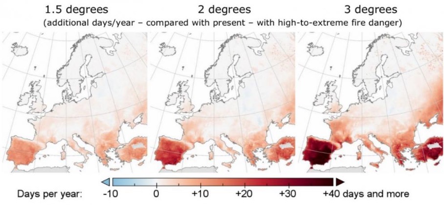
Figure 2 : The projected number of extra days with high to extreme fire danger based on increases in the mean global temperature. Source: Joint Research Center Peseta IV Technical Report on Wildfires. [JRC Peseta]
Current Tools in Wildfire Response
A key shortcoming in human-based fire monitoring is in patrolling remote areas of forest, where it is impractical to patrol large swaths of land continuously. Apart from land- and air-based patrols, many forest services maintain cameras and sensors in particular locations of forests. Naturally, it is impractical to maintain the same density of devices in more remote areas, so the high quality of the collected, ground-truth data is offset by its lack of availability in these areas. This is where other remote sensing techniques come in.
Satellite-based earth observation techniques have improved drastically in the last twenty years. These techniques are due to improve as the data processing and hardware on the satellites improves. However, there are currently some severe limitations which discount the sole use of these techniques to manage fires. Firstly, the resolution of the sensors is limited (a) temporally or (b) spatially. As an example, Jang et al published a method [Jang2019] to detect and monitor forest fires in South Korea based on geostationary satellite data, stating that fires less than 1ha were hard to detect, but that their method could detect fires within ten minutes. Second, cloud cover and smoke generated by the fires themselves present challenges for data collected at many wavelengths, but especially optical, based data.
In the area of forest fire detection, the material from the last ten years and is too great to address directly. We direct the interested reader to the following review paper of research methods for using drones in early wildfire detection [Abdemalek22].
Improving Wildfire Response Through Drone-Informed Smoke Modeling
Given that wildfires are posing a greater threat to greater populations across Europe, is Europe planning on doing anything about it? Indeed, the TEMA project has many goals to help with the increased amount of climate-change-related emergencies throughout Europe, and we will mention here specifically those methods which involve unmanned aerial vehicles, more commonly known as drones.
One important sub-project in improving forest fire management is in developing state-of-the art models for forest fires which work in real-time. Improvements in computer hardware are now making it possible to perform complicated modeling of critical factors such as smoke plumes and fire spread, with lower run times. If such a model runs in real-time, as TEMA aims to achieve through its partnership with the German Aerospace Agency (German abbreviation DLR), it could provide firefighters and affected communities key information to help manage the spread of fires and the community response.
Improved modeling goes hand in hand with more capable remote sensing technologies. A drone mounted with sensors could provide such models with a ground truth, giving indicators to its potential accuracy. The DLR is looking at ways to incorporate such remotely-collected drone data into running its models. In addition to infrared and optical data, the drones will be equipped with specialized sensors of key trace gases of wildfires, such as PANs, ozone, and nitrogen oxides. In addition to simply improving model performance, such data collection could be used to find out where the source of the fire is based on the concentrations of smoke observed, a so-called inverse problem.
It is also important to note that the increased risk of wildfires may require changes in policy from governments to discourage urban development in areas newly deemed too high a risk for fires. Higher quality models of smoke plume and forest fire spread could better inform these necessary regulations.
Conclusions
The increasing worldwide risk of forest fires and increasing technological advances of the last several years combine to make research in forest fire modeling and management more attractive than ever. The TEMA project aims to make meaningful progress in emergency management in wildfires using methods which will include smoke plume modeling and drone sensors – domains in which satellite and fixed sensors are currently not able to provide enough information.
Bibliography:
[EFFIS] European Commission, Joint Research Centre, San-Miguel-Ayanz, J., Durrant, T., Boca, R. et al., Advance report on forest fires in Europe, Middle East and North Africa 2022, Publications Office of the European Union, 2023, https://data.europa.eu/doi/10.2760/091540
[JRC Peseta] Feyen L., Ciscar J.C., Gosling S., Ibarreta D., Soria A. (editors). Climate change impacts and adaptation in Europe. JRC PESETA IV
final report. EUR 30180EN, Publications Office of the European Union, Luxembourg, 2020. https://dx.doi.org/10.2760/171121,
JRC119178
[Jang19] Jang, Eunna, Yoojin Kang, Jungho Im, Dong-Won Lee, Jongmin Yoon, and Sang-Kyun Kim, Detection and Monitoring of Forest Fires Using Himawari-8 Geostationary Satellite Data in South Korea, Remote Sensing, Vol. 11, No. 3, January 30, 2019, p. 271. https://dx.doi.org/10.3390/rs11030271.
[Abdemalek22] Abdelmalek Bouguettaya, Hafed Zarzour, Amine Mohammed Taberkit, Ahmed Kechida, A review on early wildfire detection from unmanned aerial vehicles using deep learning-based computer vision algorithms, Signal Processing, Volume 190, 2022, https://doi.org/10.1016/j.sigpro.2021.108309.