

Methodology and Processing of the Model for the Forest Fire Risk Map

Fabio Casule, Civil servant at the emergency planning service at Direzione generale della protezione civile Regione Autonoma della Sardegna (RAS).
Renata Brattina, Unit coordinator General Affairs and Technical Activities at Direzione generale della protezione civile Regione Autonoma della Sardegna (RAS).
Valeria Chiara Coraini, Unit coordinator - Communication and International Activities at Direzione generale della protezione civile Regione Autonoma della Sardegna (RAS).
Francesco Nasir, Civil servant at the risk forecasting service at Direzione generale della protezione civile Regione Autonoma della Sardegna (RAS).
From the 4th to the 7th of December 2023, two joint conferences (namely IEEE/ACM BDCAT and UCC) regarding the state-of-the-art technologies and applications in the field of big data and cloud computing were held in the Sicilian town of Taormina. RAS participated with its own contribution, concerning the "Methodology and Processing of the Model for the Forest Fire Risk Map" with particular regard to the application of Deep Learning to the Regional Fire Plan of the Sardinia Region.
The aim of the work presented is to illustrate the methodology used for the elaboration of the risk map, starting from cartographic bases, in order to obtain a product in raster format that allows rapid spatial analysis in a GIS environment for processing. Risk, in the context of civil protection activities, is understood as the probability of a calamitous event occurring that can cause harmful effects on the population, infrastructure, residential and productive settlements within a given area and within a given period of time. The 'risk scenario' thus consists of the preventive assessment of the effects, understood as damage, that may occur as a consequence of calamitous events on the population, territory, goods and essential services, and consequently the assessment of the probable progressive and final developments that these effects produce in the chain of command and response actions.
The objective of the research is to be able to determine the Hazard Index and the Municipal Risk Index, which respectively define the degree of hazard and the fire risk calculated on a regional basis and referred to the individual municipal territory, exploiting the typical functionalities of GIS technology and the innovation and potential of artificial intelligence, with the ultimate aim of transforming the algorithms into automated processes to be used in platforms that return outputs to end users.
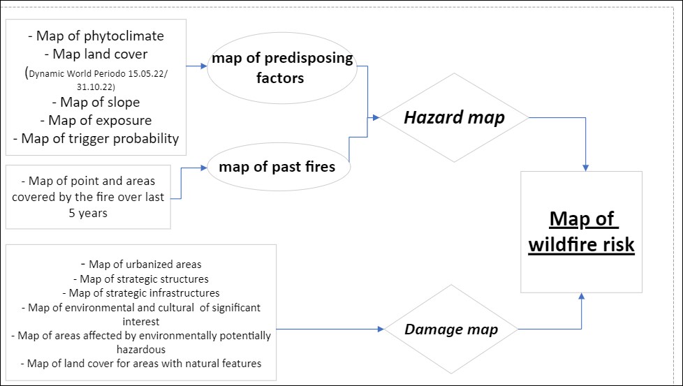
As mentioned above, the elaboration of maps is a decisive step in the prevention and planning of fire-fighting strategies. Specifically, the Hazard Map is obtained by superimposing data in raster format from the following maps:
- Probability map based on predisposing factors and drawn up considering specific factors, such as phytoclimatic belts, land use, trigger probability, slope and exposure, data that are in turn processed, also with the support of artificial intelligence algorithms, and reported in special maps.
- Map of past fires, compiled from data on areas covered by fire in the last five years.
The Damage Severity or Potential Damage Map expresses the damage or negative consequences that forest fires cause in the environment with which they interact, and in turn is drawn up on the basis of data expressed in 6 different maps (urbanised areas, strategic infrastructures historical and cultural environmental assets of significant interest, areas affected by industrial or technological economic activities potentially dangerous to the environment) that also illustrate the weights, assigned according to the potential damage/gravity class (5 classes, from almost nil to high), that express the fire's destructive potential on the element considered.
Finally, the Risk Map is created from the weighted summation of the hazard map and the severity map, and the risk class is represented with increasing values that assign different weights to the hazard.
The regional maps, as well as the related elaborations, are considered indicative and decision-supporting for planners at the local scale, and thanks to the continuous study and technological evolution, and the consequent improvement of algorithms and weightings, they are susceptible to implementation during the planned annual updates.
The analysis of the outputs obtained from the application of the algorithms presented can be a valuable aid in supporting decision-making both for assessing the exposure to danger and for organising the forces in the field in active combat.
Increasingly accurate, organised and structured data can certainly be a powerful tool for improving processes and operations.
In this work, the need to acquire increasingly precise data has led to the introduction of the Dynamic World land use map in the processes for drawing up hazard and risk maps. However, having a lot of structured data can certainly lead to the development of new outputs that could define in even greater detail the areas in which to intervene to reduce both the hazard and the risk. Thus, it also introduces economic-financial planning aimed at supporting the elimination, if not completely, then at least a portion, of the fire hazard and risk with direct interventions.
It remains desirable to automate all the operations performed by means of model builders, integrating them into the recent civil protection platform of the Sardinia Region called SIPC (Sistema Integrato di Protezione Civile - Integrated Civil Protection System) so that the different entities at the various levels - regional/provincial/municipal - can have access to the same cartography, scaled for their own territorial level, in an automated but coordinated and coherent manner.
The research work described above fits coherently into the TEMA project, since the updating of the forest fire hazard and risk maps, and consequently of the maps on which they are built, has also been achieved using an artificial intelligence application, through deep learning, i.e. Dynamic World.
In accordance with the relevant Italian regulations, the aim is to translate into programming code (R or Python) all the operations carried out locally/at the edge in the GIS software used by "Model Builder" to construct the maps; the aim is to translate into programming code (R or Python) all the operations carried out locally/at the edge in the GIS software used by "Model Builder" to construct the maps; then, to bring back the developed algorithms, standardised on the basis of the scientific literature and the work of the offices in charge of the production of the hazard/risk maps and the location of the exposed population, and then to encode them in a cloud platform that can perform the computations or receive them for further processing, so that the various bodies at different levels - regional/provincial/municipal - can have access to the same cartography, scaled to their own territorial level, in an automated but coordinated and consistent manner.