

Leveraging Information Fusion for Enhanced Natural Disaster Management

Abdalraheem Ijjeh, Postdoctoral Researcher at at GRVC Group, University of Seville
Natural disasters are becoming more frequent in modern times, which means that advanced management and mitigation techniques are required. The swift advancement of technology in several fields has enabled the collection and processing of data from multiple sources regarding monitored events. As a result, information fusion effectiveness becomes an important strategy that allows data from many sources to be combined in order to produce accurate assessments of emerging crises. Seeking to provide insights on human life protection and ways to lessen the effects of catastrophic events, this article explores the importance of the information fusion approach and its application in a variety of natural disaster management (NDM) contexts.
What is information fusion
The process of integrating data from several input sources, including satellites, drones, weather stations, seismic detectors, and Internet of Things (IoT) devices is known as information fusion. Information fusion seeks to overcome the limits of individual input sources and provide a more comprehensive and accurate view of the environment by merging data from many sources. Typically, there are multiple steps involved in the information fusion process: data acquisition, preprocessing, and data registration (e.g. synchronizing timestamps from different sensors or georeferencing data from various locations). Next, feature extraction, information association, and finally, estimation and decision-making.
Importance of information fusion in NDM
- Enhanced Situational Awareness: Decision-makers can now have a thorough grasp of the changing disaster scenario due to information fusion. Real-time updates on environmental conditions, infrastructure damage, and population movements are estimates via information fusion, which integrates measurements from several inputs, including weather forecasts, geosocial media, images captured by drones and satellite images. Making informed decisions during all stages of disaster management, from preparation and reaction to recovery and reconstruction, depends on having this improved situational awareness.
- Enhanced Disaster Response: Sensor fusion makes it easier to prioritize interventions and coordinate resources during disaster response operations. Emergency responders can evaluate infrastructure damage, determine regions of highest need, and deploy resources efficiently. This makes it possible for emergency responses to be more effective and focused, ultimately saving lives and reducing the effects of the disaster event.
- Post-Disaster Evaluation and Recovery: Information fusion plays a critical role in the timely evaluation of damage following a natural disaster, as well as in the planning of recovery and reconstruction efforts. Authorities can swiftly assess the amount of damage, identify major infrastructure risks, and create plans for repairing and boosting resilience by combining satellite data, ground-based sensors, and aerial imagery.
The TEMA project
At the University of Seville, one of our primary tasks is to develop an information fusion technology for the TEMA project. This technology is designed to continuously assess the status of monitored natural disaster events in near real-time. To accomplish this, the information fusion module integrates various inputs from resources that present vast temporal and spatial heterogeneity. The figure below presents the general approach of the information fusion technology.
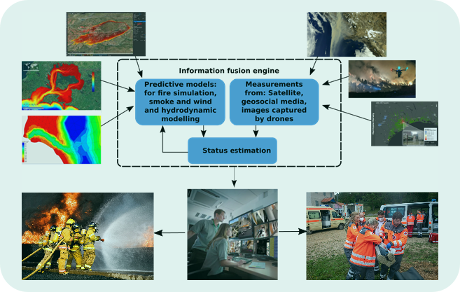
Figure 1: Infusion model engine
Information fusion facilitates the precise estimation of the current status of monitored events in real-time and delivers this information to relevant stakeholders.
- Flood monitoring: The information fusion module makes it possible to monitor and estimate the status of flood events by combining data from satellite imaging, weather forecasts, and predictive models. The rapid issuance of flood alerts and the early evacuation and deployment of resources to impacted areas are made possible by real-time data fusion.
- Forest wildfire monitoring: Information fusion combines data from e.g. thermal imaging cameras, satellite imagery, and ground-based weather stations in addition to predictive models to detect and track wildfires in real-time. Information fusion techniques support firefighting efforts and evacuation planning, helping to minimize the spread of wildfires and protect vulnerable communities.
In TEMA project, information fusion plays a crucial role in enhancing our ability to monitor, predict, and respond to natural disasters effectively. By integrating data from multiple sources, this module provides the end-users with enhanced situational awareness, enables the development of early warning systems, and improves disaster response coordination. As the frequency and severity of natural disasters continue to rise due to climate change and other factors, utilizing information fusion technology will be essential for building more resilient and disaster-resilient communities. By leveraging the power of information fusion, we can better protect lives, property, and the environment from the devastating impacts of NDM.