Canadian Wildfires & the US East Coast: How Wildfires can affect people far away

13 June 2023
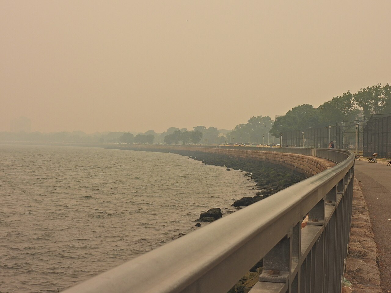
A smoke cloud on the East Coast
On the 7th of June, New York City was covered in orange smoke. All over the internet, it is possible to find pictures of the most famous symbols of the Big Apple with this unusual background, from the Statue of Liberty to Manhattan’s skyscrapers and Time Square (Debusmann et al., 2023; Dennis & Koh, 2023). Moreover, local institutions recommended wearing masks outdoors, a baseball game at the Yankee Stadium was rescheduled, as a WNBA basketball game in Brooklyn, and flights in LaGuardia Airport and Newark Liberty International Airport were grounded due to low visibility (Clifford, 2023; Dennis & Koh, 2023; Yan et al., 2023).
However, NYC was not the only city affected, a National Women's Soccer League match in close by New Jersey (Clifford, 2023), but the whole East Coast was hit: in Philadelphia, another MLB game was postponed, schools cancelled field trips, moved recess indoors and postponed athletic matches (Clifford, 2023; Dennis & Koh, 2023; Yan et al., 2023); meanwhile, in Washington D.C., monuments were covered by the orange smoke and all outdoors events were cancelled, like the White House's planned pride celebrations (Debusmann et al., 2023; Dennis & Koh, 2023). Altogether, 13 US states issued air quality alerts, from Vermont to South Carolina and far west as Kansas, accounting for 75 to 100 million people (Clifford, 2023; Debusmann et al., 2023; NASA, 2023; Pultarova, 2023; Yan et al., 2023).
This massive cloud of smoke came from Canada, where numerous wildfires were active, at the same time, in Quebec and Nova Scotia. It was pushed southward by a large area of low air pressure above the northwestern parts of the Atlantic Ocean (Dong et al., 2023; Pultarova, 2023). Its origin made the smoke even more dangerous because, when it is caused by wildfires, it contains the smallest-particle pollutant, PM2.5, and according to NASA, in New York, Philadelphia and other cities in the region, its concentration was higher than the record high, on the 7th of July 2002 (Pultarova, 2023; Yan et al., 2023).
Why Canadian wildfires are so disruptive this year
Except for the storm that pushed the cloud south, the cause of the smoke getting this far is the number of wildfires occurring in Canada during this springtime. While it is not uncommon to have a wildfire season from May until October, fires are more widespread and destructive this year, and more Canadian provinces are involved, like the usually less-hit Nova Scotia (Korte, 2023; Williams, 2023). According to experts, this wave of fires originated from one of the warmest e driest springs in history, with all Canadian provinces experiencing droughts, and the jet stream weakened by the warming in the Arctic (Debusmann et al., 2023; Korte, 2023). Even if it cannot always seem meaningful, even a tiny change in the average temperature can have severe consequences: for example, most wildfires in Quebec are started by lightning and a one-degree Celsius increase in temperature amounts to about 12% more lightning (Dong et al., 2023; Korte, 2023; Williams, 2023). Furthermore, fire seasons are getting longer and longer due to Climate Change, and we risk experiencing more episodes like those from June 2023.
During the first six months of 2023, 2300 wildfires burnt over 3,8 million hectares, 13 times worse than the 10-year average, displacing over 120 thousand people (Clifford, 2023; Dennis & Koh, 2023; Korte, 2023; Williams, 2023; Yan et al., 2023). Only in Quebec, Nasa registered 1550 square kilometres of burnt land in 6 months, while the yearly average is 2,6 square kilometres (NASA, 2023; Pultarova, 2023).
Wildfires are a health threat
To understand the massive effects that wildfires can also have far from where they start, it is helpful to look at how the smoke deteriorated the air quality on the East Coast. Based on the Air Quality Index (AQI), a measurement above 100 is considered "unhealthy", whereas more than 300 is "hazardous" (Clifford, 2023; Yan et al., 2023). In NYC, on the 7th of June, the AQI was 484, which was by far the worst air in the world, above Dubai (168), New Delhi (164), and Lahore, as it was in other parts of the US – Washington (293), Pennsylvania (410) – and North America – Alberta (338) (Clifford, 2023; Debusmann et al., 2023; Yan et al., 2023). To better explain these numbers, as stated before, wildfires smoke is hazardous, it can irritate the eyes, throat and sinuses, causing cough and heavy breathing, more over PM2.5, again the smallest pollutant, can travel deep into lung tissue and even enter the bloodstream, causing serious illnesses, especially to those most vulnerable – elders, pregnant women and children (Clifford, 2023; Dennis & Koh, 2023; Yan et al., 2023). Last, the World Health Organization (WHO) demonstrated that wildfires smoke impacts can be deadly, reporting 4.2 million deaths associated with fine particulate matter (Yan et al., 2023).
Keeping Wildfires under control: The TEMA project
Having understood how badly wildfires can affect people’s life even far away from where they are burning, it is clear how important it is to be prepared and able to keep wildfires under control.
The “Trustely Extreme Precise Mapping and Prediction for Emergency Management” (TEMA) project has been started by a group of universities, companies and institutions within the Horizon Europe framework to manage Natural Disasters better. In fact, it aims to improve Natural Disaster and Emergency Management by using new technologies – like AI and an algorithm that extracts information from extreme data – to 3D-map the area affected and model and real-time predict the evolution of the emergency phenomenon. The maps and simulations will be then used by rescue operators – such as Civil Protection Agencies and First Responders – to evaluate alternative response strategies and to orient themselves in the area thanks to an augmented reality platform.
TEMA will be helpful also in dealing with wildfires because, through the data collected, the created platform will know which parts of forests and woods can be more subjected to ignition due to the kind of vegetation or morphological structure and how a hypothetical wildfire would develop in a given area. Implementing this project will help first rescuers' decision-making, and the wildfire will always be under control and easier to extinguish, causing less damage to people and nature.
References
- Clifford, T. (2023). “US East Coast blanketed in veil of smoke from Canadian fires”. Reuters. Retrieved from: https://www.reuters.com/business/environment/us-states-under-air-quality-alerts-canadian-smoke-drifts-south-2023-06-07/.
- Debusmann Jr, C. B. et. al (2023). “Canada wildfires: US East Coast sees worst air quality in years”.BBC. Retrieved from: https://www.bbc.com/news/world-us-canada-65828469.
- Dennis, B. & Koh, J. (2023). “Smoke from Canadian wildfires engulfs East Coast, upending daily life”.Washington Post. Retrieved from: https://www.washingtonpost.com/climate-environment/2023/06/07/air-quality-nyc-us-canada-wildfire-smoke/.
- Dong, M. et al. (2023). “Maps: Tracking Air Quality and Smoke From Canada Wildfires”. New York Times. Retrieved from: https://www.nytimes.com/interactive/2023/us/smoke-maps-canada-fires.html.
- Korte, C. (2023). “How did the Canadian wildfires start? A look at what's causing the fires that covered the East Coast in smoke”. CBS News. Retrieved from: https://www.cbsnews.com/news/how-did-the-wildfires-in-canada-start-cause-nova-scotia-quebec/.
- NASA. (2023). “Fires Burn Across Quebec”. NASA Earth Observatory. Retrieved from: https://earthobservatory.nasa.gov/images/151430/fires-burn-across-quebec?utm_source=TWITTER&utm_medium=NASAEarth&utm_campaign=NASASocial&linkId=218563773.
- Pultarova, T. (2023). “Satellite photos show US East Coast engulfed by smoke from Canadian wildfires”. Space.com. Retrieved from: https://www.space.com/satellite-photos-canada-wildfire-smoke-us-east-coast.
- TEMA. (2023). “Description of the Project”. Retrieved from: https://tema-project.eu/project-description.
- Williams, N. (2023). “Where are the Canada wildfires and are they under control?”. Reuters. Retrieved from: https://www.reuters.com/world/americas/why-are-wildfires-raging-canadas-eastern-nova-scotia-province-2023-06-02/.
- Yan, H. et al. (2023). “Intense smoke fills NYC and forces a ‘code red’ in Philadelphia as millions from the East Coast to Canada suffer from Quebec’s wildfires”. CNN. Retrieved from: https://edition.cnn.com/2023/06/07/weather/new-york-air-pollution-canada-wildfires-climate-wednesday/index.html.

