

Assessment with New Methods and Strategies During the Flood in Ahrtal, Germany, in Summer 2021

Mihalic Dogan, M., Bavarian Red Cross- HQ Munich
Kippnich, U., Bavarian Red Cross- HQ Munich
Dr. Wieland, M., German Aerospace Center (DLR)- German Remote Sensing Data Center (DFD)
In June 2021, Germany experienced the biggest natural disaster in its recent history due to flash floods that hit Western Germany. Experts say that floods like this occur once in 1000 years. Two days before the flood, a warning was issued by the German Weather Service (DWD) predicting 80 to 180 litres of rain per square meter, but that amount was exceeded the following night with 200 litres per square meter. Hot and dry weather in the weeks prior to the floods dried the soil and reduced its capacities to absorb the rainwater, which further intensified the floods in many areas. Places in North Rhine-Westphalia and Rhineland-Palatinate were particularly affected.
Of all areas, the Ahrtal took the worst hit, because of its specific geographical setting in a steep and narrow valley without natural retention areas. On July 15th 2021, at 14:30 the level of water measured at Altenahr gauge was 1,38 meters. At 19:30 it was 3,92 meters and by 23:00 it reached almost 7 meters. In direct consequence of the flood in Ahrtal region 133 persons lost their life, and 1 person is still presumed missing. Over 800 people were injured, some seriously. Around 23,000 private households were affected, as well as around 7,000 companies and self-employed people. There was a heavy damage on the public infrastructure, leaving people without electrical supply and drinking water or telecommunications. Roads and bridges were also badly damaged: 62 of 112 bridges were destroyed, 13 of them partially. Civil protection services in the area were also affected, with infrastructure damaged and persons hurt.
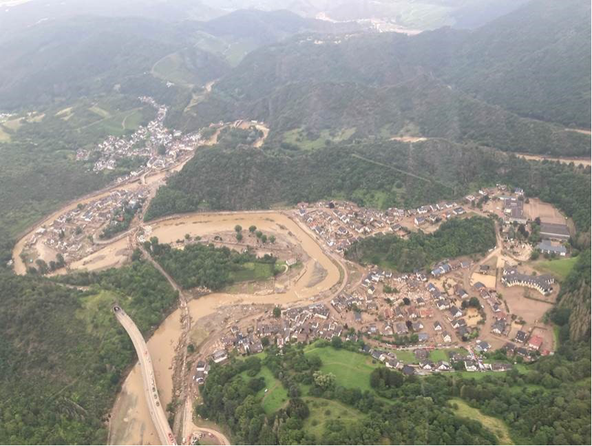
Destroyed places and roads in the Eifel (view from the helicopter on July 16, 2021). Source: @DLR 2021
First days of the mission
The alert from the German Weather Services (DWD) was issued on Tuesday, July 13th 2021, predicting heavy rain, which in the next few days led to flash floods in Western Germany. It was Saturday, July 17th, early in the morning, when the state office of the Bavarian Red Cross in Munich alerted the Medical Task Force 47 of Lower Franconia/Bavaria as part of the cross-regional disaster relief system with the assignment to provide regional aid and to be prepared for a time of at least 72 hours of self-sufficient deployment. At 6:00 p.m., 11 hours after the alert was raised, the entire BRK formation reached the Nürburgring Racetrack which was the assembly area. This was the meeting point for the incoming assistance and the base for the onsite operation and coordination center (OSOC). The command post gave the situation overview with very few information on the situation and affected area.
Throughout Germany, there are 61 Medical Task Forces (MTF) stationed. These units can operate self-sufficiently in the field for 48 hours and provide medical support. The MTF have around 130 staff members and 50 vehicles that include ambulances, technical trucks, field kitchens. The structure of the Task Force is: command, transportation, logistic and in future experts and equipment for decontamination of the contaminated injured persons.
Countless public protection and disaster relief units from Germany and neighbouring countries, as well as armed forces, including various helicopters, as well as special units which provide food, sheltering, medical support on different levels, mobile rescue station and advanced medical posts had also arrived the disaster area. Due to the vastness of the area affected by the naturel disaster, and the countless rescue units, it was difficult to get an overview of the situation. Previously established connections and friendships with other units’ commanders were helpful in solving that problem because they could provide some initial information on the situation. Later an initial briefing was given by a representative of the supervisory and service directorate.
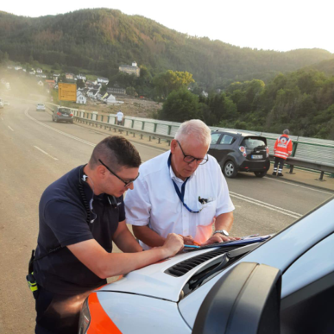
Medical Task Force 47 commander with the local on-site commander in Ahrtal, July 2021. Source:@BRK 2021
During the entire duration of the deployment and especially at the beginning, local managers were present at the staff meetings and were able to give very specific information on the situation and handle with any problems that arose directly with the possibilities on site without having to deal with long reporting channels. During the day that followed, the local command structure was divided into three equal levels. The political administration based on supervisory and service directorate, the technical operational management based on the edge of the affected area and the section health, directly working with the command post in the field. This tactical structure was set up and operated by the state government, at the Nürburgring and at the Federal Academy for Civil Protection and Civil Defence (BABZ) in Ahrweiler. In view of the severely damaged infrastructure and the associated dangers such as unsecured damaged power or gas lines, destroyed roads and bridges and houses in danger of collapsing, an operation was only carried out from sunrise to sunset for safety reasons.
Priority of the units was to provide first aid and rescue service in the affected area. After that, setting up housing and sanitation and providing food (breakfast, warm lunch, and dinner) for more than 5.000 affected people. The teams from the MTF were also involved in search and rescue operations. Since the beginning of the flood more than 1.000 person were missing. With help from helicopters, drones and on the ground assistance, the operation was ongoing. In the coming days the affected infrastructure was rebuild and a professional attempt was made to reactivate the system. Since more than 60 bridges were destroyed or affected, which caused a great problem to find access to the region.
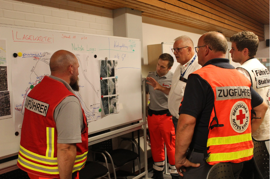
Briefing of the platoon leaders and mission planning, basic for to plan of action during the Ahrtal flooding . Source: @BRK 2021
Assessment team (G.I.L.T)
Natural disasters caused by extreme weather occur in Germany at ever shorter intervals with dramatic consequences. The response to these events, alongside existing tactical units, require special concepts and operational materials to protect the population as best as possible. As a pilot unit, the first G.I.L.T. tam was set up by the Bavarian Red Cross in Lower Franconia with the support of the German Aerospace Centre (DLR) in the field of situation and location assessment.
G.I.L.T. stands for: Terrain (Germ. Gelände), Infrastructure, Logistics and Transport. The vehicles used by the G.I.L.T team are designed in such a way that they can also be used off-road outside the regular road network. In cases when the critical infrastructure is destroyed or not available, the team can still reliably reach the site and provide aid. A wide variety of information sources are integrated for situational assessments and to optimize operational logistics. The unit can ensure the transport of patients, rescue workers and material even under extreme conditions.
The G.I.L.T. team supported a rescue mission in the Ahrtal. At first, the team made an assessment in order to identify disaster hot spots and the local needs. The team worked closely with the Center for satellite-based crisis information (ZKI) of the German Aerospace Centre (DLR) to check specific points of interest for mapping and get an overview of the situation by providing before and after satellite images. The team is equipped with special all-terrain vehicles. One of those is the 8x8 amphibious “ARGO”. This vehicle can be used for different purposes: transport of persons or patients with stretcher, transports of materials needed, food, water, or equipment.
In the future, the missions of the G.I.L.T. will be evaluated and rated. Based on the findings, the number of personnel, vehicles, material, as well as the tactics will be adjusted. The aim in the medium term, is to have such a unit in every Bavarian administrative district.
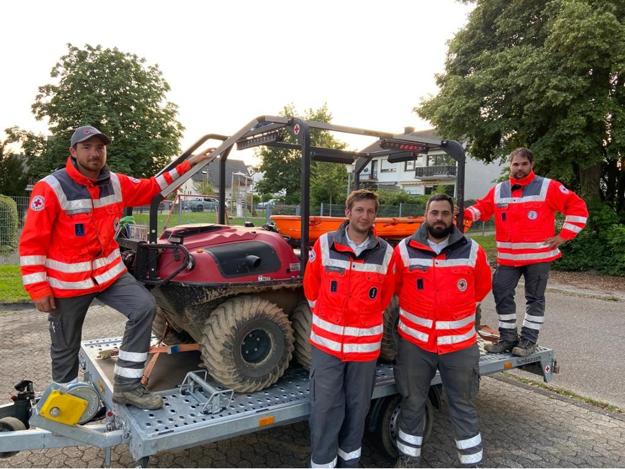
Part of the G.I.L.T. team on mission in Ahrtal. Source: @BRK 2021
New methods with AI
The Center for satellite-based crisis information (ZKI) of the German Aerospace Center (DLR) supported the natural disaster management during the Ahrtal flooding with up-to-date aerial and satellite images as well as flood information products derived from the images. Flood inundation maps were created on the basis of Sentinel-1 radar satellite images. These maps illustrate the extent of the water areas over large areas. For a more detailed situational picture on particularly affected areas, DLR's own camera developments of the Remote Sensing Technology Institute (IMF) and the Institute of Optical Sensor Systems (OS) were deployed on helicopter and planes to acquire centimetre-scale aerial images. Images were directly processed on-board into ortho-photos to enable further rapid mapping by the ZKI. The images and maps were created as part of the AIFER research project in close cooperation with the Bavarian Red Cross (BRK) and the German Red Cross (DRK). AIFER develops artificial intelligence (AI) methods that automatically recognize and merge information from satellite data, aerial photographs, and media. The Federal Ministry of Education and Research BMBF funds the project.
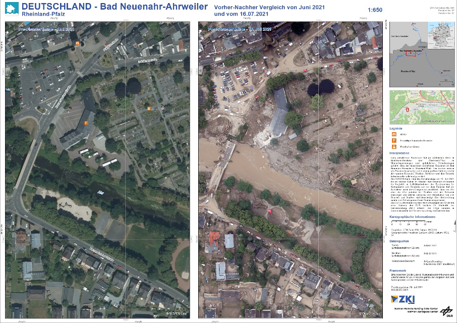
Germany , Bad Neuenahr-Ahrweiler flood, before and after comparison from July 16, 2021. Source: @DLR 2021
Lessons Learned
- New situations need new conceptions
- Training is the basic for the mission success
- Rapid mapping products derived from satellite and aerial images contributed to the success of the mission
- Maps that compare satellite and aerial images before and after situation are of great help
- Rapid mapping protocols need to adjust to changing data availability (more data at higher frequency available during disasters) and end-user requirements (rapid delivery, thematic content, etc.)