
Background Image for header that show a weather storm
tema logotipo
Home

Main navigation

  • Home
  • About
    • Description of the project
    • Partners
    • Governance
    • Glossary
  • Cluster
  • Pilots
  • Outcomes
    • Datasets and Publications
    • Public deliverables
    • Academic Contents
    • Dissemination materials
    • Videos
  • Updates
    • Articles
    • News
    • Events
    • Newsletters
  • Contact
  1. Home
  2. Hazard Map

Hazard Map

Hazard map for forest fire

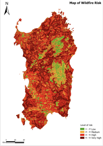
Methodology and Processing of the Model for the Forest Fire Risk Map

Thu, 01/02/2024 - 10:00
The articles seeks to illustrate the methodology used for the elaboration of the risk map, starting from cartographic bases, in order to obtain a product in raster format that allows rapid spatial analysis in a GIS environment for processing. It is based on the work previously presented "Methodology and Processing of the Model for the Forest Fire Risk Map".
Subscribe to Hazard Map
Tema logo

Contact us

info@temaproject.eu

Join our newsletter

CC-BY Licence

Footer Links

  • Privacy
  • Cookies
  • Glossary
  • Accessibility Statement
  • Sitemap
EU Funded This project has received funding from the European Union’s HE research and innovation programme under the grant agreement No. 101093003